A naukri.com initiative
Insider
1d
296
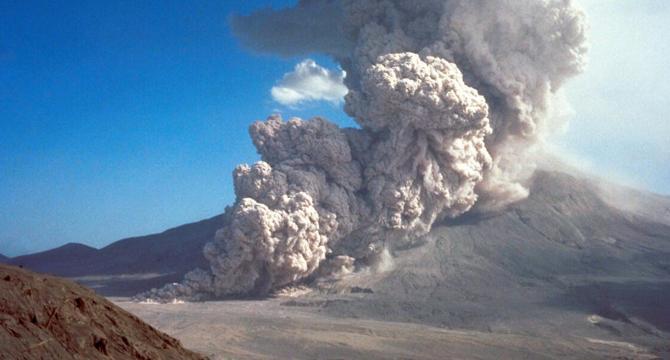
Image Credit: Insider
Photos show the eruption of Mount St. Helens, the worst volcanic disaster in US history, 45 years ago
- On May 18, 1980, an earthquake caused the eruption of Mount St. Helens, resulting in immense devastation, mudslides, explosions, and plumes of ash.
- This catastrophic event led to the death of 57 people and significant changes in how the US monitors and prepares for volcanic eruptions.
- The eruption caused a collapse of the mountain's conical top, sending rivers of mud and rock down its slopes and ash clouds across a vast area.
- The eruption's aftermath resulted in the destruction of trees, bridges, and over $1 billion in damages, marking it as the most destructive volcanic eruption in US history.
- Scientists had predicted Mount St. Helens' violent eruption due to the volcano's historical behavior and signs of unrest leading up to the event.
- The eruption's devastating impact included debris avalanches, pyroclastic flows, mudslides, and ash plumes that traveled hundreds of miles, affecting multiple states.
- The disaster killed 57 individuals, including USGS geologist David Johnston, and spurred advancements in volcano monitoring and hazard prediction technologies.
- Following the eruption, a new ecosystem gradually emerged around Mount St. Helens, showcasing the resilience of some plant and animal species despite the destruction.
- Scientific research post-eruption led to the establishment of the Cascades Volcano Observatory, contributing to volcano monitoring and training initiatives.
- Although Mount St. Helens has had smaller eruptions post-1980, improved monitoring technology allows for better prediction and preparedness for potential eruptions.
Read Full Article
17 Likes
For uninterrupted reading, download the app