A naukri.com initiative
TechnologyReview
4w
365
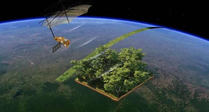
Image Credit: TechnologyReview
The world’s biggest space-based radar will measure Earth’s forests from orbit
- The European Space Agency and Airbus have built a satellite called Biomass to measure Earth's forests' carbon capturing capacity.
- The satellite will use a long-prohibited band of the radio spectrum to see below treetops globally.
- Due to the limitations of direct measurement, biomass is typically assessed indirectly through field sampling and remote sensing technologies like lidar scanners.
- Space-based forest sensing is crucial for less-mapped regions like the Amazon jungle, where ground studies are limited.
- The Biomass satellite employs P-band radar, allowing it to penetrate forests and measure tree mass more effectively.
- The satellite's size and the ban on P-band radar systems in space posed challenges, leading to exemptions and restrictions on its operation over certain regions.
- The mission aims to map biomass in various global forests and understand their role in the carbon cycle over the course of five years.
- Biomass will provide detailed 3D maps of tropical forests but may not capture seasonal variations and cannot measure carbon trapped in permafrost areas.
- Despite its limitations, Biomass will offer valuable insights into carbon storage in forests and the impact of disturbances like deforestation and fires.
- This mission contributes significantly to understanding the global carbon cycle and the threats faced by dense tropical forests.
Read Full Article
22 Likes
For uninterrupted reading, download the app