A naukri.com initiative
Bioengineer
1d
360
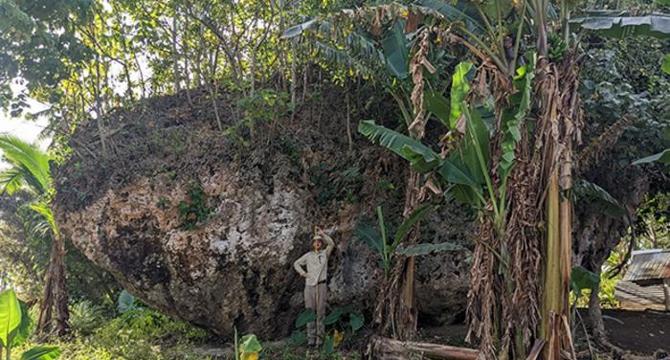
Image Credit: Bioengineer
Boulder Washed Ashore: Evidence of Pacific Tsunami History
- Researchers have discovered the largest known cliff-top boulder, the Maka Lahi boulder, on the island of Tongatapu in Tonga, challenging previous tsunami wave transport assumptions.
- This colossal boulder, weighing 1,200 tonnes and measuring 14 by 12 by 6.7 meters, was likely dislodged and transported by a powerful tsunami event around 7,000 years ago.
- Advanced 3D modeling techniques were used to estimate the forces required to displace the boulder, suggesting tsunami wave heights of about 50 meters and sustained energy for 90 seconds.
- The discovery offers crucial insights into the geological history and future tsunami hazard risks of the Pacific region, particularly in Tonga's tectonically complex environment.
- Published in Marine Geology, the study highlights the interdisciplinary approach that enhances tsunami research and coastal hazard assessment globally.
- The researchers aim to improve models of tsunami hydrodynamics, rock entrainment, and sediment transport under extreme wave conditions, aiding in coastal hazard management.
- The discovery emphasizes the significance of understanding prehistoric tsunami occurrences for enhancing risk assessment, mitigation strategies, and early warning systems in vulnerable coastal areas.
- The resilience of the Maka Lahi boulder over millennia provides valuable insights into ancient tsunami events in the Pacific and their interaction with coastal topography.
- This groundbreaking study challenges existing paradigms of tsunami wave dynamics and encourages a reevaluation of tsunami hazard potential in island nations and vulnerable coastal zones.
- Future research inspired by this discovery aims to identify similar records globally, forecast tsunami impact zones, and enhance early warning systems using empirical constraints on wave heights and run-up distances.
Read Full Article
21 Likes
For uninterrupted reading, download the app