Hackers-Arise
1d
228

Image Credit: Hackers-Arise
Can Artificial Intelligence Be Used to Track Your Location?
- Exif data containing GPS information in photos have been used to track the location and habits of users on social media in the past. However, AI technology is revolutionizing geolocation by tracking users through photos online. GeoSpy is an advanced Visual Place Recognition (VPR) system that uses artificial intelligence to find a photo's location by analyzing the pixels in the image. GeoSpy uses advanced embedding models to turn raw pixel data into numerical representations and analyzes various visual clues to create a comprehensive picture of how these elements interact. GeoSpy is an invaluable tool for open-source intelligence (OSINT) investigators, law enforcement, and security professionals.
- GeoSpy uses AI to analyze everything from architectural styles and infrastructure elements to cultural indicators, making it more accurate than earlier landmark recognition systems. GeoSpy is used to verify news photos, trace viral content, check the authenticity of visual evidence, locate missing persons, and identify locations in surveillance footage, among other things.
- One of the most impressive features is that GeoSpy understands the relationship between different elements in an image and makes sense of ambiguities. The science of visual analysis works through several layers, making it highly accurate.
- GeoSpy's main technology, Superbolt, is built on years of research in computer vision, which creates compact mathematical representations of features in photos. These representations capture details like textures, building styles, and environmental factors.
- Infrastructure elements, such as streetlights, road markings, and utility installations, are another key focus of GeoSpy. These elements often follow regional standards and are highly location-specific.
- GeoSpy can account for variations in lighting, seasons, and even years by comparing current photos with historical reference images. This includes factoring in changes like new buildings or urban growth, allowing it to estimate when a photo was taken. Weather patterns also contribute to GeoSpy's analysis.
- GeoSpy's vector search capabilities enable it to perform complex analyses quickly by generating compact embeddings that capture various visual elements and comparing them to its large database of reference images.
- GeoSpy's ability saves time and resources of the investigators. Using GeoSpy, they can trace viral content, authenticate photos and enhance safety. Insurance companies also verify claim photos, while online marketplaces check the authenticity of product images. Dating apps use it to stop users from faking their location and to enhance the user's safety.
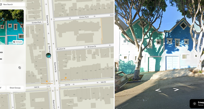
- GeoSpy Superbolt's demo page can be accessed for free. Users can upload an image, and Superbolt will display possible location(s) where the photo was taken, often pinpointed on a map.
- The science of visual analysis has made GeoSpy an essential tool for investigators, journalists, and professionals in OSINT. Speed is critical, as targets move often. Legal enforcement and the financial industry can use GeoSpy to prevent fraud.
Read Full Article
13 Likes
For uninterrupted reading, download the app