A naukri.com initiative
Livescience
3w
78
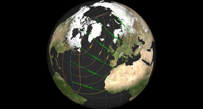
Image Credit: Livescience
Eclipse map: Will the March 29 solar eclipse be visible in your state?
- A partial solar eclipse will occur on Saturday, March 29, 2025, visible in 13 U.S. states, parts of northeastern Canada, western Europe, and Africa.
- The East Coast of the U.S. and Canada will witness the largest portion of the sun being blocked out, creating a 'devil horns' effect during sunrise.
- NASA released a map showing the eclipse path, revealing the extent of sun coverage and peak times in various locations.
- The eclipse will peak at different times in locations like St. John’s, Canada; Boston; New York City; and London, covering varying percentages of the sun.
- Over 800 million people will be able to witness the partial eclipse, with live streams available for those not in the viewing path.
- Eye protection is crucial to observe the eclipse safely, with NASA warning against looking directly at the sun without proper equipment.
- Avoid using cameras, telescopes, or binoculars to look at the sun during the eclipse without certified solar filters to prevent eye damage.
- Missing the March 29 eclipse, another partial eclipse will be visible in September 2025, with a total solar eclipse in 2026 across various regions.
- Solar eclipses occur when the moon passes between the Earth and the sun, casting a shadow on Earth's surface and blocking out sunlight.
- It is essential to follow safety guidelines when watching solar eclipses to prevent eye injuries from the sun's rays even during a partial eclipse.
Read Full Article
4 Likes
For uninterrupted reading, download the app