Drones News
Dronelife
400

Image Credit: Dronelife
Zing Drone Solutions Wins $100K at Counter-UAS Challenge for Airspace Security Innovation
- Zing Drone Solutions has won the $100,000 grand prize at the Proven in Pendleton Counter UAS Challenge for their Z-SCAN drone detection technology.
- Z-SCAN uses passive radio frequency-based detection and machine learning to track drones and their operators in real-time.
- The system works in poor weather conditions and does not require jamming or active signals for operation.
- Zing plans to target correctional facilities, airports, stadiums, and other critical infrastructure for their security technology.
Read Full Article
24 Likes
Insider
319

Image Credit: Insider
NATO warships in the Red Sea fight are proving that deck guns can fight a drone war
- NATO warships in the Red Sea have utilized their deck guns to take down Houthi drones, proving the weapon's relevance in modern warfare.
- Deck guns offer a cost-effective alternative to expensive surface-to-air missiles for destroying drones.
- Naval artillery guns and autocannons on NATO warships have been effectively used in recent months to intercept hostile drones.
- The French military frigate successfully destroyed a Houthi drone with a deck gun in the Red Sea, showcasing the weapon's efficacy.
- The use of deck guns by NATO warships highlights their value in a maritime drone combat scenario, providing a more economical solution.
- US Navy destroyers have also engaged in successful shoot-downs of drones using their deck guns.
- The Mark-45 five-inch deck gun mounted on US destroyers and cruisers has been instrumental in destroying drones and missiles.
- While surface-to-air missiles are commonly used for defense, deck guns present a valuable short-range kinetic capability.
- Deck guns are particularly effective against slower targets like small attack drones, offering a swift and affordable countermeasure.
- Naval tactics suggest that deploying multiple rounds from a deck gun can saturate the sky with shrapnel, enhancing defense capabilities.
Read Full Article
19 Likes
Dronelife
294
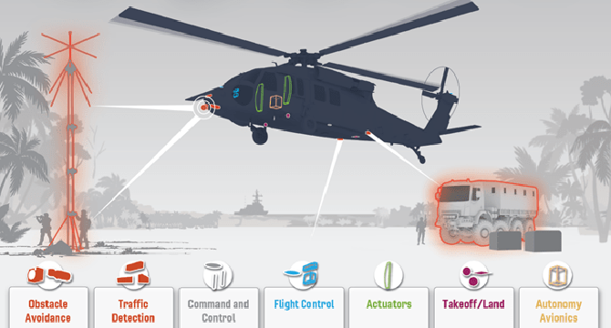
Image Credit: Dronelife
U.S. Army Selects Near Earth Autonomy and Honeywell to Retrofit Black Hawks for Autonomous Logistics
- The U.S. Army has selected Near Earth Autonomy and Honeywell for a $15 million project to retrofit UH-60L Black Hawk helicopters with advanced autonomy kits.
- The goal of the project is to develop an optionally piloted contested logistics solution that can operate 24/7 without onboard crews and remote pilots.
- Near Earth's deterministic autonomy architecture, called Captain, ensures mission assurance in degraded environments without GPS or reliable communications.
- Honeywell provides scalable and certifiable avionics solutions to support the retrofitting of existing aircraft and enable advancements toward autonomous flight.
Read Full Article
17 Likes
Dronevideos
350

Image Credit: Dronevideos
One of New York’s Largest Cities Finally Gets a Police Drone Program
- The city of Syracuse, New York, has implemented a drone program for its police department.
- The program was initially met with opposition due to concerns about civilian privacy and civil liberties.
- The program, called the Drone as First Responder (DFR) program, is funded by city funds and a state grant.
- The drones will be stationed in key locations across the city and will be dispatched to respond to 911 calls.
Read Full Article
21 Likes
Dronelife
319

Image Credit: Dronelife
How Integrated Technology Partnerships Are Transforming Police Operations: New Collaboration Aims to Streamline Emergency Response and Crime Prevention
- Mark43 and Flock Safety have partnered to provide integrated public safety solutions.
- The partnership aims to streamline emergency response and improve access to real-time intelligence.
- Key benefits of the integration include unified workflows, enhanced evidence management, faster emergency response, and improved security.
- The collaboration reflects the industry trend of seeking open, interoperable platforms for better decision-making and future-proofing technology investments.
Read Full Article
19 Likes
Tech Radar
184
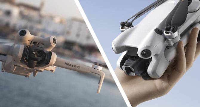
Image Credit: Tech Radar
DJI Mini 5 rumors take flight – here are 5 major upgrades on my beginner drone wishlist
- The first leaked image hints at possible LiDAR technology in the upcoming DJI Mini 5 Pro drone.
- Rumored improvements in the Mini 5 include a larger sensor for enhanced video quality and better stability during flights.
- Speculations suggest DJI Mini 5 may debut in August or September 2025, building on the success of Mini 4 Pro.
- LiDAR sensors could provide improved collision avoidance, particularly in low-light conditions, making flying safer.
- Larger motors in the leaked image hint at potentially longer flight times and better wind resistance for stability.
- The Mini 5 might feature a 1-inch sensor, offering better image quality in various lighting conditions compared to its predecessors.
- The drone's design with propellor guards could indicate a new direction for the Mini series, although not confirmed yet.
- The possibility of Mini 5 exceeding 250g due to added features raises concerns over potential restrictions for beginners.
- Fans await more details on the Mini 5 Pro's features, such as potential upgrades in video resolution and flight time.
- It remains to be seen if the speculated upgrades justify any potential increase in weight over the Mini 4 Pro.
Read Full Article
11 Likes
TechCrunch
229

Image Credit: TechCrunch
Near Space Labs nabs $20M to take its high-res imaging Swift robots into the stratosphere
- Near Space Labs has secured $20 million in funding to further develop its high-resolution imaging technology using Swift robots that float into the stratosphere using helium balloons.
- The funding round was led by Bold Capital Partners, with participation from USAA, Climate Capital, Gaingels, River Park Ventures, and other existing backers, bringing the total raised by Near Space to over $40 million.
- The company's founders, Rema Matevosyan, Ignasi Lluch, and Albert Caubet, all have backgrounds in space and physics technology and research.
- Near Space was born out of a collaboration between the Skolkovo Institute in Russia and MIT, with the founders later moving to the U.S. for opportunities like the Urban-X accelerator program.
- Despite the closure of the Skolkovo-MIT partnership and Urban-X accelerator, Near Space continues to grow and expand its operations from the U.S.
- By capturing high-resolution imagery from the stratosphere using Swift robots, Near Space has found traction with customers in sectors like insurance, aiding in disaster tracking.
- The company aims to cover 80% of the U.S. population twice a year with its 7cm imagery, offering faster and more accurate results compared to drone or satellite imaging.
- Near Space plans to customize coverage plans for different sectors, potentially expanding beyond insurance into areas like agriculture.
- While military usage is a potential market, Near Space is currently focused on commercial applications given its Swift technology's versatility and cost-effectiveness.
- Investors see value in Near Space's low-cost aerial imaging technology, particularly as AI applications require high-quality and timely data.
Read Full Article
13 Likes
The Drone Girl
22

BILD Expo 2025: a standout event for drone photographers (and it’s free!)
- BILD Expo 2025 at Javits Center in New York City is a must-attend event for drone photographers and other creatives, offering hands-on access to the latest gear.
- Launched in 2023, BILD Expo has grown to become a significant event after the cancellation of other iconic expos like Photokina and PhotoPlus.
- The 2025 edition of BILD Expo expects a larger turnout with free registration, diverse speakers, and support from over 250 exhibiting brands.
- B&H Photo's Chief Marketing Officer views BILD Expo as an energetic gathering of creatives focused on education and community building.
- Drone pilots, in particular, can benefit from BILD Expo's programming that covers aerial imagery, filmmaking workshops, and technological advancements.
- The event offers live demos, panel discussions, B&H show specials, photo walks, networking opportunities, and keynotes from industry leaders.
- Notable speakers at BILD Expo 2025 include Cristina Mittermeier, Elena Buenrostro, and Scott Kelby, making it a valuable experience for drone enthusiasts.
- BILD Expo, rooted in B&H's legacy, serves as a hub for the creative community with its dedication to education, collaboration, and community support.
- The event remains free to attend, setting it apart from many industry conventions that come with a professional price tag.
- BILD Expo 2025 is set to take place on June 17–18, offering an immersive experience for drone photographers and creatives in New York City.
Read Full Article
1 Like
BGR
202
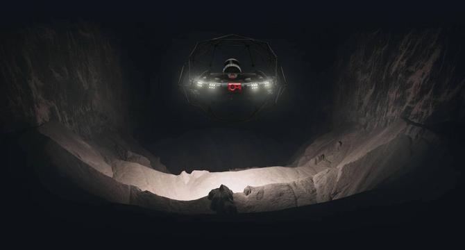
Image Credit: BGR
The secret to cleaner, safer sewers just might be ‘poop drones’
- Inspecting aging sewer pipes has traditionally been slow, dangerous, and costly. Drones like Elios 3 and Asio X are specifically designed to navigate dark, cramped spaces, capturing detailed data without putting human workers at risk. Software like SewerAI processes footage from the drones using artificial intelligence to detect cracks, blockages, and structural defects, reducing costs, increasing inspection speeds, and improving defect detection accuracy. As more cities invest in these drones and AI-powered tools, inspections will become safer, faster, and more reliable.
Read Full Article
12 Likes
The Verge
396

Image Credit: The Verge
The DJI Phantom is no more
- DJI, the Chinese drone manufacturer, has officially announced the end of life for its Phantom line of drones.
- The Phantom drones, including the Phantom 4 Pro and Phantom 4 Advanced, will no longer be in production and service for these models will be suspended on June 1st, 2025.
- The Phantom series played a significant role in making DJI a dominant player in the drone market, with their ready-to-fly quadcopter cameras becoming popular among both consumers and video production professionals.
- DJI has shifted its focus to other drone models, such as the Mavic, Air, Mini, and the upcoming Flip line.
Read Full Article
23 Likes
Insider
292

Image Credit: Insider
Uncrewed warships are simple answers to big US Navy problems, says a defense tech company that's building them
- The US Navy is facing shipbuilding and fleet size challenges in preparation for potential conflicts, particularly with China's growing maritime strength.
- Blue Water Autonomy, a defense tech company, sees uncrewed warships as a cost-effective solution to the Navy's problems.
- They believe uncrewed vessels can supplement the traditional fleet and offer capabilities at a lower cost.
- The company is developing fully autonomous warships to operate alongside crewed vessels.
- Blue Water aims to produce autonomous warships that can travel long distances, operate independently, and carry large payloads.
- These autonomous vessels could help address the gap in the Navy's preparedness for potential conflicts.
- Blue Water's focus on autonomous warships aims to enhance the Navy's capabilities without overburdening shipyards or the current shipbuilding industry.
- The company plans to build prototypes at a faster pace, utilizing medium-sized shipyards across the US.
- Survivability and combat capabilities, including kinetic defensive systems, are key considerations in designing these autonomous warships.
- Other countries like Ukraine have demonstrated the feasibility of arming uncrewed surface vessels with weapons, showcasing the evolving landscape of naval warfare.
Read Full Article
17 Likes
Dronelife
373

Image Credit: Dronelife
Racing Into the Future: How Abu Dhabi Is Accelerating Autonomous Innovation on the Drone Radio Show!
- ASPIRE, the program management and business development arm of the Advanced Technology Research Council in Abu Dhabi, is accelerating autonomous innovation through international competitions and grand challenges.
- Stéphane Timpano is the CEO of ASPIRE, overseeing the strategic direction and relationships with key stakeholders and partners.
- Recently, the Autonomous Drone Racing Grand Championship took place in Abu Dhabi, where MavLab from the Delft University of Technology secured victories in three out of four competitions, showcasing the potential of autonomous drones in racing.
- In this episode of the Drone Radio Show, Stéphane shares insights into ASPIRE's mission and the broader impact of autonomous racing challenges across technology, education, and industry.
Read Full Article
22 Likes
Dronelife
193
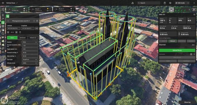
Image Credit: Dronelife
SPH Engineering Releases UgCS 5.9: Greater Precision, New Features for Mission Planning
- SPH Engineering released UgCS 5.9, an update to their flagship software.
- New features include explicit altitude settings for photogrammetry and corridor missions.
- The update also introduces enhanced elevation data for US users and UI improvements.
- UgCS is a leading flight-planning software for drones used in over 150 countries.
Read Full Article
11 Likes
Dronelife
148

Image Credit: Dronelife
5 Ways Drone Technology is Revolutionizing Urban Building Maintenance
- Drone technology is revolutionizing urban building maintenance by improving safety, cutting costs, and enhancing sustainability.
- Drones keep workers on the ground, reducing height-related safety risks and leading to zero safety incidents in drone-based operations.
- Specialized cleaning drones equipped with advanced systems access building exteriors while operators remain safe on the ground.
- Drone cleaning operations result in an average cost reduction of 40-50% compared to traditional methods, with significant savings and efficiency improvements.
- Advanced drone technology includes detailed inspections with imaging capabilities like thermal imaging and AI-powered defect detection algorithms for early issue identification.
- Drone technology reduces environmental impacts by conserving water, lowering chemical usage, reducing carbon emissions, and minimizing noise pollution.
- Drone maintenance can integrate with smart building systems for precise maintenance planning, automated scheduling, and data-driven optimization.
- Challenges like regulatory considerations and technical obstacles in urban drone operations are being addressed through best practices and innovative solutions.
- Future trends in drone maintenance include autonomous operations, expanded service capabilities, AI-powered maintenance planning, and integration with emerging technologies.
- The integration of drone technology into urban building maintenance offers safety enhancement, cost reduction, advanced capabilities, environmental benefits, and smart building integration, transforming the industry.
Read Full Article
8 Likes
The Drone Girl
103

Drone industry funding in 2025 is low: should small businesses, drone hobbyists panic?
- The commercial drone industry is facing a tough period with low funding in 2025, causing worries for small businesses and hobbyists.
- Investment in drone companies has been declining sharply, with investments dropping from $3.67 billion in 2021 to $820 million in 2024.
- The industry is in the 'Trough of Disillusionment,' where only the strongest companies may survive, leading to a reshaping of the future of drones.
- Small drone businesses are facing survival challenges, with options like merging, pivoting, or closure due to less venture capital availability.
- Hobby pilots may experience higher costs and fewer options due to fewer startups and tariffs, especially on drones imported from China.
- The industry is maturing, with practical adoption taking precedence over hype, offering new opportunities in defense and public safety.
- To thrive in this period, small drone businesses and pilots can diversify skills, advocate for better regulations, and watch advancements in the defense sector.
- Despite funding challenges and regulatory headwinds, the long-term outlook for drones remains positive, with innovation set to define the future of flight.
- The drone industry is projected to see further changes and opportunities, indicating a tough yet promising phase for businesses and pilots.
Read Full Article
6 Likes
For uninterrupted reading, download the app