Drones News
Dronelife
205
Image Credit: Dronelife
Sony Launches World’s Smallest and Lightest Precision LiDAR Sensor
- Sony Electronics has introduced the AS-DT1, a compact and lightweight LiDAR depth sensor for precise 3D measurement.
- It is now the world's smallest and lightest precision LiDAR sensor, weighing only 50 grams and measuring 29mm x 29mm x 31mm.
- The AS-DT1 utilizes Sony's proprietary Direct Time of Flight (dToF) LiDAR technology, enabling accurate measurements of length, width, and depth.
- This sensor is suitable for various applications including drones, robots, and structure inspections in challenging environments.
Read Full Article
12 Likes
Dronelife
378

Image Credit: Dronelife
Proposed Drone Integration and Zoning Act (S.1249): Still a Bad Idea
- The Drone Integration and Zoning Act (S.1249) is causing concern in the commercial drone industry as it would grant states, localities, and tribal governments regulatory authority up to 200 feet above ground level.
- S.1249 proposes significant changes, including allowing entities to regulate drone operations below 200 feet, prohibiting drone operations without landowner permission, and setting restrictions near tall structures.
- The bill limits FAA authority below 200 feet, mandates the creation of complex airspace designations and zoning processes, and requires data-sharing with UAS Traffic Management services.
- Concerns arise due to potential operational inefficiencies, legal risks, and the fragmentation of regulations hindering interstate drone operations, especially for Beyond Visual Line of Sight (BVLOS) operations.
- S.1249's property rights focus may increase compliance costs, compromise safety, and complicate long-range drone operations, creating a patchwork of rules that could impede drone service providers.
- Unresolved conflicts include the clash between the 200-foot threshold and FAA's 400-feet operational ceiling, potential clashes with free speech rights, and the risk of conflicting rules at state and local levels.
- Industry stakeholders advocate for federal preemption below 400 feet to support safe drone integration and streamline regulatory processes, aligning with the FAA's UAS traffic management framework.
- The future of U.S. drone operations and the integration of drones into the national airspace could be significantly impacted by the ongoing debate surrounding S.1249.
- The bill's approach poses challenges for the development and scalability of drone services, potentially hindering the industry's progress towards routine BVLOS operations and large-scale applications.
Read Full Article
22 Likes
Dronelife
355

Image Credit: Dronelife
SimActive Releases Correlator3D Version 10.4 with Enhanced 3D Model Controls
- SimActive Inc. has released Version 10.4 of its Correlator3D platform.
- The new version offers advanced tools for photogrammetry and LiDAR data.
- Version 10.4 allows users to customize parameters and have full control over 3D model generation.
- Improved true ortho workflow in the update enhances final orthomosaic outputs for better visual clarity and accuracy.
Read Full Article
21 Likes
Dronelife
269
Image Credit: Dronelife
China’s Rare Earth Export Restrictions: What They Mean for the U.S. Drone Industry
- China's recent decision to restrict exports of rare earth elements poses new challenges for the U.S. drone industry.
- The export controls target materials essential for manufacturing high-performance magnets and batteries for commercial drones, raising concerns about supply chain stability and production costs.
- The restrictions have led to immediate uncertainty as shipments from China are paused and approval for export licenses may take up to two months.
- The prices of these rare earth materials have already started to rise, which will likely result in increased costs for drone manufacturers and customers.
Read Full Article
16 Likes
The Drone Girl
369

New data around drone industry value in 2025 suggests better outlook than expected
- New estimates project the global drone market to be worth $57.8 billion by 2030, up from $40.6 billion in 2025, indicating a more positive outlook for the industry.
- The Drone Market Report 2025-2030 by Drone Industry Insights highlights the growth potential in commercial drone applications, particularly in industries like construction, agriculture, energy, logistics, and public safety.
- Despite challenges in the consumer drone market, the commercial sector is thriving due to drones becoming indispensable tools in various sectors.
- The commercial services segment, including drone operation services, is projected to reach $29.4 billion by 2025, followed by the drone hardware industry valued at $6.7 billion.
- The global drone industry is witnessing significant growth in regions like Asia, North America, and Europe, with Asia leading in the number of drone flights.
- Regulatory challenges, lack of new funding, overregulation, and competition are identified as hurdles facing the drone industry, impacting innovation and growth.
- The report emphasizes the importance of software in drone operations, with the software segment estimated to be worth $1.7 billion in 2025, supporting functions like automated flight planning and data analysis.
- The evolving complexities in the industry call for addressing issues such as regulatory challenges, funding fluctuations, and market competition for sustained growth and innovation.
- Although the industry faces obstacles, the positive projections for the drone market in 2025-2030 suggest growth opportunities and advancements that could reshape the industry landscape.
- For more details from the Drone Market Report and insights on the drone industry's future, readers are directed to the original article on The Drone Girl website.
Read Full Article
22 Likes
Firstquadcopter
433
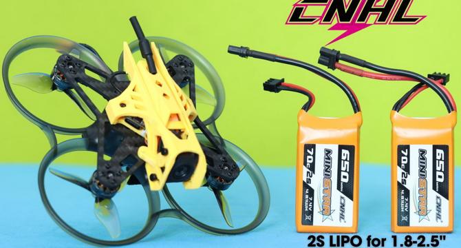
Image Credit: Firstquadcopter
CNHL 2S 650mAh 70C: MiniStar for Micros!
- The CNHL 2S 650mAh MiniStar batteries are designed for high-performance flights for 2-inch CineWhoop-style drones, offering a 70C/140C discharge rate for ample power.
- CNHL, known for producing quality LiPo batteries, offers the MiniStar series ideal for FPV drones, with the 2S 650mAh version being compact and powerful.
- The battery has a 70C discharge rate, providing reliable power for drones while maintaining stability and durability over multiple flights.
- Priced at $13.98 per pair or $27.96 for a set of four, the CNHL 2S 650mAh batteries are available worldwide with warehouses in different regions for faster delivery.
- Safety recommendations include never leaving charging batteries unattended, using dedicated LiPo chargers, balance charging, verifying charger settings, and avoiding over-discharge during use to prevent damage.
- FirstQuadcopter has provided a detailed review of the CNHL 2S 650mAh MiniStar batteries, ensuring unbiased testing and evaluation to help consumers make informed purchasing decisions.
- With technical parameters including a capacity of 650mAh, voltage of 7.4V, discharge rate of 70C continuous and 140C burst, these batteries are suitable for 2-inch drones.
- The battery dimensions are 15X30X58mm, weighing around 44 grams, with an output connector of 16AWG + XT30U and a balance connector of JST/XH.
- During testing, the batteries provided an average flight time of 3 minutes for a drone weighing 115 grams, demonstrating suitable performance for 2-inch drones.
- CNHL emphasizes the importance of following safety guidelines for using, charging, and storing the batteries to prevent accidents and ensure longevity.
Read Full Article
26 Likes
Dronelife
246
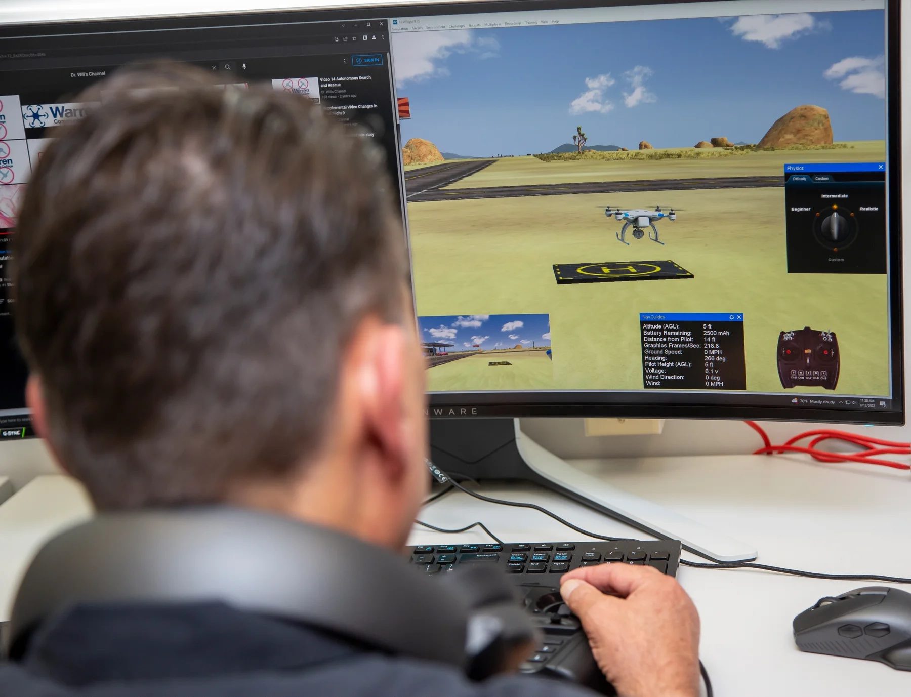
Image Credit: Dronelife
WarrenUAS Expands Industry Reach Through New Partnership with The Tactien Group
- Warren County Community College’s WarrenUAS program partners with The Tactien Group for UAS expertise and strategic insights.
- The collaboration aims to enhance research, training, and program growth in the UAS sectors.
- Nathan (Nate) A. Ernst of The Tactien Group commends WarrenUAS for its leadership in unmanned systems education.
- Ed Celiano, an expert in large-scale UAS operations, joins WarrenUAS as a consultant and instructor.
- The partnership focuses on integrating unmanned systems for infrastructure projects in the utility sector.
- The collaboration aims to provide students with hands-on experience in high-demand UAS areas.
- Tactien Group's expertise includes helping clients integrate manned and unmanned systems for infrastructure support.
- WarrenUAS's focus on precision agriculture aligns with Tactien's interest in diverse UAS applications.
- WarrenUAS, known for its top-tier training program, offers students pathways to advanced degrees and high-paying careers.
- The partnership reflects WarrenUAS's commitment to remaining at the forefront of UAS education and technology.
Read Full Article
14 Likes
Dronevideos
54

Image Credit: Dronevideos
Drone Pollination Could Change Strawberry Farming
- The UK Agri-Tech Centre and Polybee are collaborating on a project funded by Innovate UK to use drones for pollination in strawberry production.
- Polybee's drone pollination system aims to improve strawberry yields in grow houses used by leading UK berry supplier Angus Soft Fruits.
- The drones create controlled air movement to mimic wind pollination and collect data to support optimized growing and harvesting practices.
- If successful, the project could serve as a model for other sectors and contribute to advancements in food security and sustainability.
Read Full Article
3 Likes
Dronelife
451
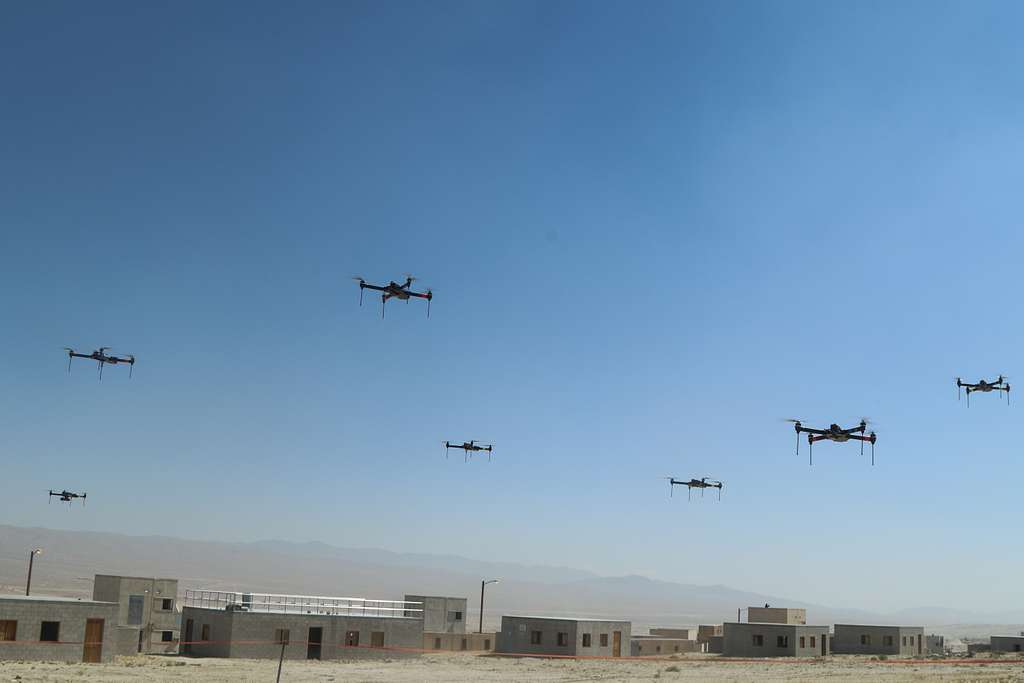
Image Credit: Dronelife
Is the Development of AI the Internet Moment for Drones?
- The development of AI in drone technology is compared to the 'Internet Moment' for personal computers, with AI redefining the capabilities of drones in commercial and military sectors.
- AI enables drones to operate autonomously, process real-time data, and make decisions independently, unlocking new possibilities for various industries.
- In commercial applications, AI expands drone capabilities in navigation, real-time data processing, precision agriculture, emergency response, and predictive maintenance.
- Swarm technology, enabled by AI, allows collaborative drone operations for mapping, search-and-rescue, and security tasks more efficiently.
- In military applications, AI enhances autonomy, precision targeting, real-time decision-making, and surveillance capabilities of unmanned aerial vehicles (UAVs).
- Common trends across commercial and military sectors include improved autonomy, real-time analytics, and swarm coordination driven by AI advancements.
- Challenges include evolving regulations for safety and privacy concerns in commercial drones, and ethical debates around autonomous weapons in military drones.
- AI-powered drones have the potential to reshape industries and defense strategies, akin to how the internet transformed personal computers, marking a significant advancement in technology.
- As AI continues to progress rapidly in drone technology, the parallels between these two technological revolutions highlight the transformative potential of AI in the drone industry.
Read Full Article
27 Likes
Dronelife
232

Image Credit: Dronelife
FAA and ASSURE Launch UAS Detection Tests at Cape May Ferry Terminal
- The FAA and the Alliance for System Safety of UAS through Research Excellence (ASSURE) have launched a testing initiative to evaluate passive drone detection systems.
- The tests will assess how well these systems work in a coastal, high-traffic maritime setting and are being conducted at the Cape May Ferry Terminal in New Jersey.
- Passive detection systems, such as acoustic sensors and radar, will be tested against a variety of commercial off-the-shelf and DIY drones in challenging environments.
- The results of the tests will help guide the FAA and stakeholders in refining drone regulations and safety protocols.
Read Full Article
14 Likes
Dronelife
241

Image Credit: Dronelife
Alaskan Drone Team Enters Active Volcano to Advance Safer Research Methods
- University of Alaska Fairbanks conducted a mission using drones to collect gas samples from Costa Rica's Poás volcano, led by research assistant professor Társilo Girona.
- The team aimed to advance safer volcano research by testing a new method of soil gas measurement using unmanned aircraft.
- The drone-based approach allowed data collection from the volcano's crater without exposing personnel to dangerous conditions.
- The mission was part of an international experiment to understand the plumbing system of Poás volcano, supported by the AVERT project.
- Poás volcano in Costa Rica has shown increased seismic activity and sulfur dioxide emissions, posing challenges for monitoring potential eruptions.
- Alaska Center for Unmanned Aircraft Systems Integration provided the team and equipment for the drone volcano mission.
- The team used two drones, including a Parrot drone for scouting and an Alta X Heavy Lift drone for sample collection using scientific instruments.
- The drones successfully collected data on carbon dioxide, water vapor, soil temperature, and moisture, crucial for understanding volcanic activity.
- The mission demonstrated the feasibility of using drones for remote soil degassing measurements in challenging volcanic environments.
- Future plans include securing additional funding to further enhance the method, expand to new volcanoes, and integrate advanced technologies.
Read Full Article
14 Likes
The Drone Girl
9

What’s the future of drone shows? Drone Cadets says it’s inside the classroom
- Drone Cadets, founded by Tony Reid, is an education program introducing people of all ages to drones and tech education.
- The program offers various curricula for different age groups, including a Mini Cadets Program and a Drone Flight School Course.
- At the Palm Springs Drone Fest, a hands-on indoor drone light show course was featured, showcasing the future of drone technology education.
- Drone Cadets focuses on practical training, teaching students the intricacies of drone light shows and providing coding experience.
- The program aims to groom students to potentially start their own drone light show companies, tapping into the market demand.
- Indoor drone shows are considered the next market trend, offering unique entertainment possibilities and job opportunities in tech.
- Reid emphasizes the safety of indoor drone shows and their potential for diverse applications in concerts, events, and performances.
- Drone Cadets not only focuses on STEM education but also on creating pathways to employment and entrepreneurship, especially for underserved communities.
- The program includes workforce development programs and certifications to help individuals secure drone-related jobs in various industries.
- Drone Cadets' vision extends beyond education to empowerment, aiming to equip individuals to take on roles in the burgeoning drone industry.
Read Full Article
Like
Insider
347
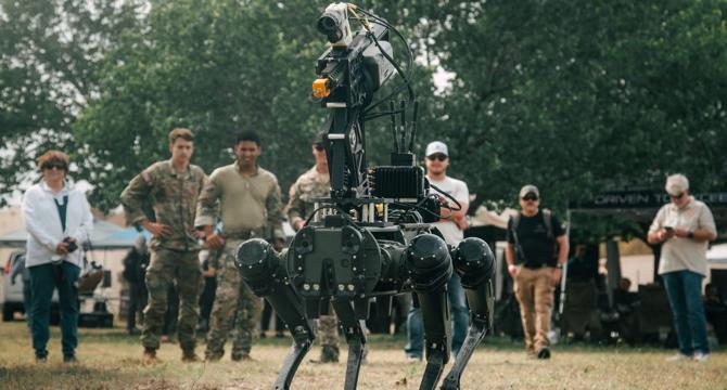
Image Credit: Insider
US special operators are going all in on drones so that a human never has to make 'first contact' with the enemy
- US special operations forces are heavily involved in working with various drones, with a focus on honing drone operating skills and acquiring different types of drone technologies.
- At the US Army Special Operations Command's Capabilities Exercise at Fort Bragg, a wide array of drones including quadcopters, ground vehicle systems, robot dogs, and loitering munitions were showcased.
- The use of drones in warfare is increasingly inevitable, with a key goal being to eliminate the need for humans to make initial contact with the enemy by leveraging drone capabilities for reconnaissance and intelligence gathering.
- Operators highlighted the adaptability and mobility of drones, particularly quadcopters which can change sensors and payloads based on mission requirements, and are relatively easy to learn and operate.
- Loitering munitions like UVision's Hero and AeroVironment's Switchblade were also on display, showing the advancements in autonomous attack drones that loiter before engaging targets.
- Robot dogs, quadruped ground drones, were another highlighted technology for enhanced reconnaissance and soldier support, offering a way to keep humans and military dogs out of harm's way.
- The rapid technological advancements in drone technology pose challenges for operators in quickly grasping different controls and specifications, while also highlighting the necessity of integrating drones into warfare strategies for potential future conflicts with peer-level adversaries.
- US special operators are adapting to the evolving landscape of modern warfare by incorporating drones into their training regimens and operational plans for potential great-power competition scenarios.
- The integration of small uncrewed aerial systems and uncrewed ground vehicles into military operations reflects a strategic shift towards preparing for a high-tech battlefield environment involving drones and electronic warfare.
- Special operators emphasize the importance of cohesive team training to ensure seamless integration of drone technologies into combat strategies and readiness for potential drone-centric conflicts in the future.
- Overall, the increased reliance on drones in military operations signifies a significant shift towards leveraging advanced technologies to enhance battlefield capabilities and prepare for evolving threats in modern warfare.
Read Full Article
20 Likes
Dronevideos
155
Image Credit: Dronevideos
Texas Schools Turn to Drones for Faster Security Response
- Texas schools are turning to drones for faster security response in the wake of a tragic mass shooting in 2022.
- Texas House Bill 3 requires all public schools to employ at least one armed officer on campus, with exemptions for financial constraints.
- Entrepreneurs Justin Martson and Bill King founded Campus Guardian Angel, a company that installs drone security systems in schools.
- The custom-made drones can respond to threats within five seconds, confront within fifteen seconds, and neutralize within sixty seconds, providing crucial time for ground officers to respond.
Read Full Article
9 Likes
The Robot Report
45

Building a universal robotics platform with BOW
- The Robot Report Podcast · Building a Universal Robotics Platform with BOW
- University of Sheffield spinout, BOW, aims to simplify the development of robotic applications through their robotics platform.
- The discussions on the podcast include the challenges in the robotics industry, the features of the BOW software development kit (SDK), and the company's business model.
- The conversation also touches on partnerships, integration with the Robot Operating System (ROS), and the future of robotics, particularly in relation to artificial intelligence and task-oriented development.
Read Full Article
2 Likes
For uninterrupted reading, download the app