Drones News
Dronelife
344
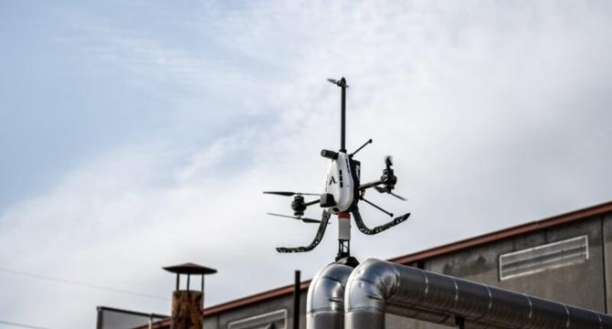
Image Credit: Dronelife
Voliro Raises $23M to Expand Aerial Robotics for Infrastructure Inspection
- Voliro, a Zurich-based aerial robotics company, secures $23 million in Series A funding to scale their autonomous drone technology for industrial infrastructure inspections.
- Voliro's drones are designed for inspecting difficult-to-reach structures like flare stacks, chimneys, and wind turbines using a patented tiltable-rotor design and modular payload system.
- The funding will be used to enhance the Voliro T platform with cloud integration, autonomy, and AI tools for more frequent and automated inspections.
- The technology addresses the need for safer and more efficient inspections as aging industrial assets and workforce gaps in non-destructive testing pose challenges.
- Voliro's drones have already gained traction globally with over 40 companies in 17 countries utilizing them for contact-based inspections, especially in the energy and renewables sectors.
- The company's drones are reported to perform lightning protection system inspections in wind farms five times faster than manual methods, reducing costs and downtime.
- The investment from venture capital firm noa highlights Voliro's potential to transform industrial infrastructure maintenance through automation and robotics.
- Voliro aims to revolutionize infrastructure maintenance by leveraging robotics, AI, and industry expertise to reduce human risk and enhance data quality.
- Voliro, a spin-off of ETH Zurich's Autonomous Systems Lab, continues to pioneer solutions that make industrial maintenance safer, efficient, and appealing to younger workers.
Read Full Article
20 Likes
Dronelife
35

Image Credit: Dronelife
Teledyne FLIR OEM Supports Secure U.S. Defense Innovation with NDAA-Compliant Thermal Imaging
- Teledyne FLIR OEM aligns with U.S. defense innovation by offering NDAA-compliant thermal imaging camera modules to strengthen domestic drone supply chains in response to executive orders by President Trump.
- The company's U.S.-built Neutrino®, Boson®, Hadron™, and Lepton® modules meet NDAA requirements and are suitable for use in various U.S. government defense contracts.
- Teledyne FLIR OEM's thermal imaging solutions are assembled and tested in the U.S., meeting NDAA regulations, classified as non-ITAR, and falling under the U.S. Department of Commerce for export regulation.
- The lineup of NDAA-compliant camera modules supports defense applications and provides situational awareness for the U.S. Armed Forces and allied nations, meeting regulatory standards.
- Teledyne FLIR's NDAA-compliant thermal imaging products cater to OEMs for various defense systems, including autonomous platforms, soldier-worn systems, missile seekers, and counter-drone technologies.
- Key models offered include Neutrino LC and SX8, Neutrino QX and SX12, Boson+, Hadron 640, and Lepton, designed for easy integration into defense systems.
- The company establishes itself as supporting national strategy goals by offering compliant technologies that promote the reduction of reliance on foreign suppliers and enhance U.S. defense system cybersecurity, reliability, and availability.
- Teledyne FLIR OEM is poised to contribute to the future of secure U.S. drone operations as the government emphasizes domestic manufacturing and compliance with regulations.
Read Full Article
2 Likes
Dronelife
35

Image Credit: Dronelife
Apian Expands NHS Drone Delivery Network with Matternet Partnership
- UK startup Apian partners with American drone company Matternet to expand NHS drone delivery network in London.
- Matternet, specializing in urban drone delivery, will enhance medical logistics for NHS hospitals.
- Apian has been successful in drone delivery at Guy’s and St Thomas’ Hospitals, demonstrating improved clinical productivity and cost savings.
- The partnership aims to add more routes and strengthen NHS pathology networks, improving the processing of tests.
- Autonomous ground delivery robots will complement drone operations, streamlining logistics at hospitals.
- Apian showcased their drone and robot technology at Downing Street, emphasizing governmental support for innovative healthcare solutions.
- Collaboration with CAA and NATS ensures safety in drone operations.
- Professor Ian Abbs praises the trial for accelerating test results and sustainability, hinting at broader benefits for staff and patients.
- Matternet's CEO anticipates enhanced care delivery through faster and smarter logistics for NHS patients.
- Apian CEO Alexander Trewby highlights their infrastructure's positive impact on healthcare delivery.
- The partnership between Apian and Matternet signifies progress in medical drone delivery and logistics.
- Apian and Matternet's combined efforts aim to create seamless healthcare logistics, redirecting focus on patient care.
- The collaboration reflects a significant step in advancing medical delivery services with drone technology.
- The article covers Apian's expansion with Matternet in the UK, emphasizing innovation in healthcare logistics.
- Matternet's approval for drone operations in Saudi Arabia and launch of delivery service in Silicon Valley are mentioned.
- The news piece touches on other partnerships and initiatives within the medical drone delivery sector.
Read Full Article
2 Likes
Dronelife
317

Image Credit: Dronelife
Auterion and Taiwan’s NCSIST Partner to Advance Defense Drone Capabilities
- Auterion and Taiwan’s NCSIST have partnered to advance defense drone capabilities.
- The collaboration aims to enhance Taiwan’s uncrewed vehicle (UxV) platforms using Auterion's open-source autonomy software.
- This marks NCSIST's first international agreement in the defense tech sector and is significant for Taiwan’s national drone initiative.
- The partnership will integrate AuterionOS and AI-enabled swarming software, Nemesis, into NCSIST platforms.
- A Memorandum of Understanding (MoU) has been signed with a goal of deploying hundreds of thousands of autonomous drones in the future.
- Admiral Shi-Chiang Lee of NCSIST emphasized Auterion's capabilities in powering uncrewed systems.
- Auterion’s CEO highlighted the importance of open architectures in enabling a resilient defense strategy.
- The collaboration focuses on autonomous navigation, real-time coordination, and distributed AI for drone swarming.
- The partnership reflects a broader trend of defense collaboration between national institutions and tech firms for advanced technologies.
- Auterion and NCSIST aim to bolster Taiwan’s self-reliant defense capabilities through this partnership.
Read Full Article
19 Likes
The Drone Girl
384

Drone Legends review: A full-service STEM drone program for K–12 students
- Drone Legends aims to bring aerial robotics education to K-12 students with comprehensive kits and curricula, catering to different age groups.
- The program includes offerings like Little Legends, STEM Fundamentals, Egyptian Expedition, and FPV Initiator, focusing on teamwork, problem-solving, coding, and real FPV racing.
- The high school program, FPV Initiator, stands out for its focus on FPV racing, offering equipment like FPV goggles and drones for students to practice and compete in live races.
- Despite the program's thoroughness, the cost may be a barrier for some schools, with prices ranging from $2,999 to $12,500 depending on the kit and program chosen.
- Drone Legends also includes a Part 107 Remote Pilot Exam Prep course and is constantly evolving to meet educational needs, offering added value to schools.
- Compared to competitors like DroneBlocks, Drone Cadets, and CoDrone, Drone Legends combines flight, coding, and competition elements, making it a comprehensive option for schools.
- Schools looking to establish a long-term drone curriculum with a focus on racing and tech skills may find Drone Legends worth the investment, while smaller programs might explore more affordable alternatives.
- Overall, Drone Legends offers a well-rounded drone education platform for schools committed to integrating drones into their STEM or esports initiatives.
Read Full Article
23 Likes
Dronevideos
192
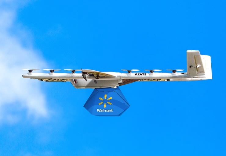
Image Credit: Dronevideos
Walmart Leads the Way in Drone Delivery With 100 Supercenters Now Delivering Across the US
- Walmart has scaled its drone delivery operations to 100 Supercenters in the US, making it the first retailer to implement drone delivery at this scale.
- The drone delivery program began with pilot programs in 2021 in Northwest Arkansas and Dallas-Fort Worth.
- Walmart partnered with Zipline and Wing for its drone delivery operations.
- Walmart's drones successfully delivered groceries, medicines, baby food, pet supplies, and ice cream.
- Walmart uses drones from Wing that can carry up to 5 lbs of payload, with a 25-minute flight time and speeds of up to 65 mph.
- The drones perform tethered drop-offs to ensure secure and contactless deliveries without needing to land.
- Walmart announced an expansion into five new major metropolitan areas, including Atlanta, Charlotte, Houston, Orlando, and Tampa.
- The drone delivery service can be scheduled through the Walmart app, website, or Wing's dedicated app.
- Walmart+ members receive free drone delivery, while nonmembers pay a flat fee of $19.99 per delivery.
- Walmart believes the drone program will revolutionize retail logistics, making shopping faster and more convenient.
- The use of electric drones for last-mile delivery by Walmart aims to reduce emissions compared to traditional gas-powered vehicles.
- Walmart's move towards drone delivery sets a precedent for other retailers and showcases its leadership in the technology.
- The Walmart drone delivery program has completed hundreds of thousands of deliveries and continues to expand.
- Drone delivery is transitioning from novelty to norm, reshaping customer expectations for fast and convenient delivery.
- Walmart's drone expansion is reshaping the retail space and pioneering advancements in last-mile delivery logistics.
Read Full Article
11 Likes
Hackernoon
278

Image Credit: Hackernoon
Ukraine, GPS, and the Problem with Smart Weapons
- In Ukraine, Western-made smart weapons like Excalibur shells, JDAM kits, and HIMARS rockets are facing challenges due to fading GPS accuracy, caused by Russian jamming and spoofing.
- Precision weapons' effectiveness dropped from over 70% to as low as 6%, costing millions for just one shot.
- Weapons like JDAM, GLSDB, and HIMARS are rendered almost useless due to GPS dependency.
- Russian forces employ GPS jamming units to manipulate enemy weaponry mid-flight, compelling a return to unguided artillery for Ukrainian forces.
- New navigation technologies like Eagle Eyes and M-GPS are emerging to counter GPS vulnerabilities, but face challenges in scalability and cost.
- The use of EW in Ukraine highlights the vulnerability of GPS-dependent systems and the need for multi-mode navigation designs in future weapons.
- China's BeiDou system poses a growing technical and geopolitical challenge to U.S. GPS dominance.
- The article emphasizes the necessity to invest in GPS-independent systems, train for GPS-denied environments, and support alternative PNT programs to adapt to the evolving landscape.
- Ukraine serves as a testing ground for the future of navigation technology and the impact of GPS reliance on warfare and technology development.
- Innovations in navigation systems during conflict shape the future of military, civilian, and commercial technology sectors.
- The consequences of relying heavily on GPS for smart weapons in warfare are prompting a shift towards multi-mode navigation and GPS-independent solutions.
Read Full Article
16 Likes
Dronelife
406

Image Credit: Dronelife
Industry Task Group Forms to Develop Drone Show Safety Standards
- A new task group under ASTM International is developing formal technical standards for drone show operations to enhance safety measures in response to a recent drone show accident in Florida.
- Drone shows, utilizing synchronized drones for light displays, have seen rapid growth globally, outpacing safety protocols.
- Price competition has sometimes prioritized cost over safety, prompting the need for standardized aviation safety practices in the sector.
- ASTM International has spearheaded the formation of the task group with industry leader Nils Thorjussen to focus on drone show safety, supported by the FAA.
- The task group encourages broad participation from stakeholders to help shape the future of drone show safety standards.
- Verge Aero has published The Essential Guide to Drone Show Safety, emphasizing five core safety elements for drone shows' safe operation.
- Drone show industry is urged to collaborate with ASTM and standards organizations to implement robust safety standards to enhance public trust and safety-first policies.
Read Full Article
24 Likes
Dronelife
340
Image Credit: Dronelife
Trump Executive Orders Push FAA to Act on Long-Awaited BVLOS Rule
- President Trump issued executive orders to boost the U.S. domestic drone industry, with a key focus on BVLOS flights.
- Industry veterans and experts lauded the directives to expedite the issuance of a comprehensive BVLOS rule by the FAA.
- The move is expected to replace the current cumbersome waiver system for BVLOS operations, optimizing tasks like inspections and deliveries.
- Efforts to establish BVLOS rules date back to 2016, with recent pushes including the formation of an ARC and congressional mandates.
- The missed deadlines led to renewed focus under the Trump administration to accelerate the Part 108 process for BVLOS regulations.
- Experts believe the executive order will drive investments in the commercial drone sector and ease restrictions on BVLOS operations.
- The emphasis on BVLOS regulations is seen as a crucial step towards expanding commercial drone operations in the U.S.
- Industry leaders anticipate significant growth opportunities once new BVLOS regulations are in place.
- The executive order aims to streamline drone operations and integration into the National Airspace System through AI tools and rule expediting.
- Overall, the industry welcomes the BVLOS push as it could open up new possibilities for drone manufacturers and operators in various sectors.
Read Full Article
20 Likes
Dronelife
227
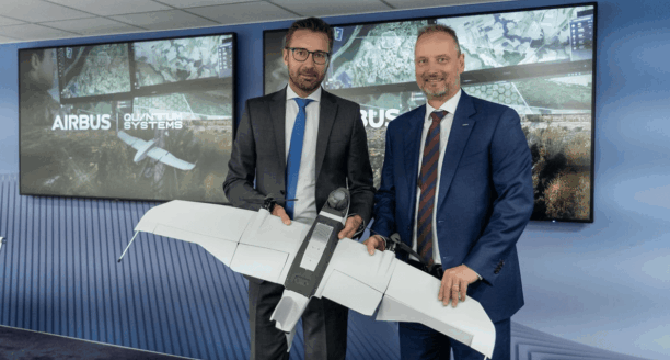
Image Credit: Dronelife
Airbus and Quantum Systems Partner to Build Open Reconnaissance Ecosystem for European Defense
- Airbus Defence and Space and Quantum Systems have signed a Memorandum of Understanding (MoU) at the 2025 Paris Air Show to enhance their strategic cooperation on tactical aerial reconnaissance solutions for European defense.
- The partnership focuses on developing interoperable, AI-powered systems to bolster European defense capabilities and sovereignty, in line with Europe's emphasis on defense readiness.
- The collaboration aims to establish an aerial intelligence network linking high-altitude platforms with low-level battlefield assets to create a networked, autonomous, and sovereign ecosystem for unmanned systems.
- Airbus and Quantum Systems prioritize transparency and open interfaces, providing European military users full control over technology, data, and upgrades.
- The companies plan to work on digital battlefields, simulation environments, and modular AI-supported mission systems to ensure rapid adoption and scalability of airborne reconnaissance tools for European forces.
- Lessons from Ukraine's evolving combat environments drive the collaboration, with Quantum Systems leveraging real-time feedback from operational deployments through its R&D and production facility in Ukraine.
- The partnership underscores Airbus' strategic vision of forming a European ecosystem in military aviation to secure Europe's sovereignty in AI-supported mission systems and crewed-uncrewed teaming.
- The alliance combines Airbus's global reach with Quantum Systems' expertise in autonomous systems to support Europe in controlling its defense technologies and advancing local innovation.
- The collaboration aligns with efforts to strengthen European defense capabilities, highlighting flexibility, transparency, and European ownership as crucial elements in future unmanned system development and deployment.
Read Full Article
12 Likes
Dronelife
371

Image Credit: Dronelife
Southern Company to Deploy SwissDrones’ SDO 50 for Infrastructure Monitoring
- SwissDrones partners with Southern Company, a major U.S. energy provider, to deploy SDO 50 unmanned helicopters for enhancing infrastructure monitoring and safety.
- The SDO 50 is a long-range unmanned helicopter designed for beyond visual line of sight (BVLOS) missions, equipped with VTOL capabilities for inspecting remote or hard-to-reach areas.
- Southern Company's adoption of the SDO 50 platform marks the first use by a U.S. energy company and demonstrates the company's commitment to innovative aerial surveillance and inspection.
- The SDO 50 reduces carbon emissions significantly compared to manned helicopters, offering a more sustainable inspection method for critical infrastructure monitoring.
- Southern Company plans to utilize the SDO 50 fleet for storm damage assessments, routine infrastructure monitoring, and modernizing inspection practices across its operations in the Southeastern U.S. and beyond.
- The unmanned helicopters can carry various sensors, such as high-resolution cameras and laser methane detectors, contributing to quicker maintenance responses and environmental monitoring.
- The customizable SDO 50 system is tailored to specific mission requirements, allowing for the incorporation of advanced sensors and artificial intelligence for enhanced data analysis.
- This deployment of uncrewed aerial systems by Southern Company represents a significant advancement in the energy sector's adoption of drone technology for safety, emission reduction, and cost savings.
- SwissDrones' partnership with Southern Company signifies the company's expansion into North America and highlights the trend of energy companies leveraging drones for operational improvements.
- Miriam McNabb, an industry expert, provides insights on the drone industry's developments and regulatory landscape, emphasizing the growth of drone technology in various sectors.
Read Full Article
22 Likes
Dronelife
79

Image Credit: Dronelife
Energy Sector Looks Ahead to FAA Action on BVLOS Rule
- The energy industry is awaiting FAA action on a BVLOS rule to enhance safety and efficiency.
- BVLOS rule could allow dispatching drones for remote well site inspections, improving safety.
- Companies advocate for regulations benefiting oil and gas industry and public safety.
- API long lobbied for BVLOS and Remote ID rules to expand drone operations.
- Routine drone inspections could enhance pipeline safety by detecting potential leaks.
- Energy companies use drones for tasks deemed dangerous for humans like tank inspections.
- Drones employed for visual inspections of hard-to-reach areas in the energy sector.
- Dow uses drones for volumetric surveys, monitoring levee conditions, and more.
- Drones help reduce hazardous tasks and increase workplace safety in the industry.
- Future drone applications may include complex tasks and non-destructive testing in energy operations.
Read Full Article
4 Likes
The Drone Girl
287

Southern Company becomes first U.S. energy utility to deploy heavy unmanned helicopters for long-range inspections
- Southern Company, the second-largest U.S. energy provider, becomes the first U.S. utility to use the SDO 50 heavy-lift unmanned helicopter by SwissDrones for long-range inspections.
- The drones can fly for over three hours, carrying advanced sensors for surveillance over rugged terrain, aiding in pipeline and power line inspections.
- The partnership between Southern Company and SwissDrones signifies a milestone in utilizing large unmanned aircraft for industrial applications.
- The SDO 50 offers extended flight times, autonomous route repeats, and a modular sensor suite for efficient data collection in remote areas.
- The deployment aligns strategically with impending BVLOS drone flight regulations in the U.S., empowering industrial UAV applications.
- Benefits include faster storm damage assessments, emission reduction by up to 95%, and improved worker safety by minimizing personnel exposure to risk.
- Utilizing heavy-lift drones over long distances enhances data gathering, service reliability, and operational efficiency for Southern Company.
- The move reflects a broader trend in the industry towards infrastructure drones for cost-effective inspection and emergency response.
- The drone market is evolving with a focus on compliance, safety, and efficiency, amidst increasing demand for autonomous UAVs in utility operations.
- The SwissDrones x Southern Company collaboration serves as a strategic model for future aerial inspection solutions in response to market and regulatory developments.
Read Full Article
17 Likes
Dronevideos
61

Image Credit: Dronevideos
Virginia Tech Receives $5 Million Grant for Drone Development
- The United States, known for pioneering drone technology, is lagging behind in the global drone race.
- Virginia Tech's Mid-Atlantic Aviation Partnership (MAAP) received a $5 million grant for drone research.
- The grant aims to establish a Counter-UAS Research and Testing Center to develop drone threat detection technologies.
- The center will focus on detecting, identifying, and neutralizing drone threats using various sensor technologies.
- It will facilitate testing counter-drone systems under realistic conditions.
- Virginia Tech aims to advance safe drone integration into commercial airspace, particularly Beyond Visual Line Of Sight operations.
- The collaboration involves Virginia Tech, MAAP, and the U.S. Army Futures Command’s C5ISR Center.
- Austin Phoenix from Virginia Tech's National Security Institute will lead the initiative.
- The collaboration intends to enhance UAS and counter-UAS capabilities through cutting-edge research.
- The U.S. seeks to reclaim its leadership in drone technology with renewed investment and research focus.
- Virginia Tech's expertise in drone testing and security research will push the bounds of drone capabilities.
- The U.S. government's goal is to advance drone deployment and defense capabilities.
- The U.S. faces a pivotal moment to shape the future of global drone technology.
- The collaboration represents an effort to bridge the gap and bolster the nation's drone capabilities.
- Virginia Tech's grant signifies a strategic move to boost U.S. drone technology leadership.
- The U.S. aims to not only catch up but also shape the future of drone technology.
Read Full Article
3 Likes
Dronelife
61
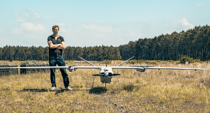
Image Credit: Dronelife
Delair Unveils DT61 Long-Range Drone with Multi-Mission Capability
- Delair has unveiled its new DT61 drone, a fixed-wing VTOL platform designed for both civilian and defense applications.
- The DT61 offers over seven hours of flight time, can communicate over 100 kilometers, and supports payloads of up to 15 kg.
- It is compact, transportable, and can be launched by a two-person crew in under 30 minutes.
- Developed in partnership with French aviation companies, the drone is set for mission deployments by the second half of 2025.
- Delair's product line includes fixed-wing drones, multirotor platforms, and loitering munitions managed by the DRAKO ground control station.
- The company's revenue has doubled year-over-year for the past three years, reaching €30 million in 2024 with a €60 million forecast for 2025.
- The DT61 will be showcased at the Paris Air Show.
- Delair has acquired SQUADRONE SYSTEM to strengthen France's drone industry and has introduced the DRAKO universal UAV ground station.
- Europe's first C6 Class drone, enabling BVLOS flights without specific authorization, has been released by DELAIR.
Read Full Article
3 Likes
For uninterrupted reading, download the app